
फाइल:Major Indo-Aryan languages.png
ऐसँ बेशी आनन्तर्य उपलब्ध नै अछि।
Major_Indo-Aryan_languages.png (५७२ × ५९९ चित्राणु, फाइल आकार: ३०३ KB, माइम प्रकार: image/png)
| ई फाइल विकिमिडिया कमन्ससँ अछि। कमन्सकs विवरण पृष्ठसँ जानकारी एतए नीचाँ देखाएल गेल अछि। कमन्स एक फ्रि लाइसेन्स मिडिया फाइल परियोजना छि। अपने मद्ददतकs सकए छि। |
सङ्क्षेप
| जानकारी |
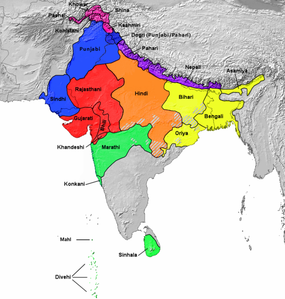
Français : Aires de répartition des principales langues indo-aryennes (carte de 1978). L'ourdou n'est pas représenté séparément du hindi. English: 1978 map showing Geographical distribution of the major Indo-Aryan languages. The western part is Proto-Indo-Europeans[1] (not shown in this map) including Medes, Persians, and Parthians [2] and Eastern Part (Urdu is included under Hindi. Romani, Domari, and Lomavren are outside the scope of the map.) Dotted/striped areas indicate where multilingualism is common.
|
||
| दिनाङ्क | |||
| स्रोत | https://upload.wikimedia.org/wikipedia/commons/archive/0/0f/20151007205526!Indoarische_Sprachen_Gruppen.png | ||
| लेखक | Filpro | ||
| दूसरे संस्करण |
This file was derived from: Indoarische Sprachen Gruppen.png
|

अधिकृत करब
इस फ़ाइल को क्रिएटिव कॉमन्स श्रेय 3.0 अनरिपोर्टेड लाइसेंस के अंतर्गत लाइसेंस किया गया है।
- अहाँ मुक्त छी:
- साझा करी – रचनाक कपी, वितरित आ सञ्चारित करवाक लेल
- रिमिक्स करैक लेल – काम अनुकूलित करैक लेल
- निम्नलिखित कारणसभक अन्तर्गत:
- एट्रीब्यूसन – अहाँक रचनाक श्रेय लाइसेन्सकर्ता अथवा लेखकके बताएल गएल माध्यमसँ देबए पडत (मुदा ई प्रकार नै की वोसँ लागै कि ओ अहाँक अथवा अहाँकद्वारा रचनाक प्रयोग क समर्थन करैत अछि)।
- ↑ https://en.wikipedia.org/wiki/Proto-Indo-Iranian_language
- ↑ https://en.wikipedia.org/wiki/History_of_Iran#Early_Iron_Age
फाइल इतिहास
तखनका तिथि/ समए पर क्लिक करी जखनका फाइल देखबाक अछि
| तिथि/ समए | लघुचित्र | बीमसभ | प्रयोक्ता | समीक्षा | |
|---|---|---|---|---|---|
| अखनका | १२:५७, २८ जुलाई २०२३ | | ५७२ × ५९९ (३०३ KB) | PadFoot2008 | |
| १४:२६, २७ जुलाई २०२३ |  | ५७२ × ५९९ (३०३ KB) | PadFoot2008 | Corrected lines based on correct linguistic classifications instead of social ones. | |
| १०:२५, २० सितम्बर २०२२ |  | ५७२ × ५९९ (३०७ KB) | Zhamidz | Reverted to version as of 16:55, 27 February 2018 (UTC). The map is different | |
| १५:३२, १७ सितम्बर २०२१ |  | ५०० × ५०० (७५ KB) | Amritsvāraya | changed the map into a more accurate map | |
| २२:४०, २७ फरबरी २०१८ |  | ५७२ × ५९९ (३०७ KB) | Mr rnddude | Bihari isn't a subset of the Hindi languages. Maithili is a language in its own right. | |
| ०६:३०, २९ अक्टुबर २०१७ |  | ८७७ × ९१९ (५८३ KB) | फ़िलप्रो | Reverted to version as of 04:41, 6 June 2016 (UTC) Updated map will be a separate image. | |
| ११:१०, २७ अक्टुबर २०१७ |  | ८७७ × ९१९ (५९४ KB) | फ़िलप्रो | Updated boundaries based off of Ethnologue, Central-Eastern and Central-Western borders changed. Fixed unnamed region between Kashmiri, Dogri, and Pahari. | |
| १०:२६, ६ जुन २०१६ |  | ८७७ × ९१९ (५८३ KB) | फ़िलप्रो | Southern Zone | |
| १०:०९, ६ जुन २०१६ |  | ८७७ × ९१९ (५८० KB) | फ़िलप्रो | Clean up. Corrections. | |
| ०९:१४, १२ जनवरी २०१६ |  | ८७७ × ९१९ (५७३ KB) | फ़िलप्रो | colours and specified groupings |
फाइलक उपयोग
ई पृष्ठमे ई फाइलक लिङ्क अछि:
विश्वव्यापी फाइल उपयोग
ई फाइल कऽ उपयोग निम्न दोसर विकिसभमे अछि:
- af.wikipedia.org कऽ उपयोग पर
- as.wikipedia.org कऽ उपयोग पर
- azb.wikipedia.org कऽ उपयोग पर
- az.wikipedia.org कऽ उपयोग पर
- ban.wikipedia.org कऽ उपयोग पर
- bh.wikipedia.org कऽ उपयोग पर
- bn.wikipedia.org कऽ उपयोग पर
- bs.wikipedia.org कऽ उपयोग पर
- da.wikipedia.org कऽ उपयोग पर
- en.wikipedia.org कऽ उपयोग पर
- Bhil languages
- Khas people
- Goaria language
- Malvi language
- Judeo-Marathi
- Dramatic Prakrit
- Shauraseni Prakrit
- Pardhi language
- Vlax Romani language
- Gamit language
- Danwar language
- Romani language standardization
- Brajavali dialect
- South Asian ethnic groups
- Shekhawati language
- Luwati language
- Ushoji language
- Dhundari language
- Abahattha
- Pashayi languages
- Shumashti language
- Sanskritism
- Sansi language
- Welsh Romani language
- Halbi language
- Kharia Thar language
- Nahari language
- Nangalami language
- Lubanki dialect
- Brokskat
- Old Hindi
- Finnish Kalo language
- Vasavi language
- Chit (consciousness)
- Tatparya
- Kadodi language
- Andh language
ई फाइलक विश्वव्यापी उपयोगक अधिक जानकारी देखी।