
फाइल:Meghalaya COVID-19.svg

पूर्वावलोकन PNG क आकार SVG फाइल: ८०० × ४३० चित्राणु दोसर resolutions: ३२० × १७२ चित्राणु | ६४० × ३४४ चित्राणु | १,०२४ × ५५१ चित्राणु | १,२८० × ६८८ चित्राणु | २,५६० × १,३७७ चित्राणु | ८०७ × ४३४ चित्राणु।
पूर्ण आनन्तर्य (एसभिजी फाइल, मामूली रूपमे ८०७ × ४३४ चित्रकण, फाइलक आकार: १५७ KB)
| ई फाइल विकिमिडिया कमन्ससँ अछि। कमन्सकs विवरण पृष्ठसँ जानकारी एतए नीचाँ देखाएल गेल अछि। कमन्स एक फ्रि लाइसेन्स मिडिया फाइल परियोजना छि। अपने मद्ददतकs सकए छि। |
सङ्क्षेप
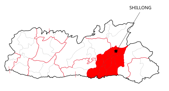
| जानकारी | This file shows the districts of Meghalaya affected by COVID-19. |
| दिनाङ्क | |
| स्रोत | Meghalaya 2012.svg |
| लेखक | Nilabh |
| दूसरे संस्करण |
[]
|


अधिकृत करब
मैं, इस कार्य का/की कॉपीराइट धारक, इसे निम्न लाइसेंसों के अंतर्गत प्रकाशित करता/करती हूँ:
इस फ़ाइल को क्रिएटिव कॉमन्स श्रेय-समानसांझा 4.0 अंतर्राष्ट्रीय लाइसेंस के अंतर्गत लाइसेंस किया गया है।
- अहाँ मुक्त छी:
- साझा करी – रचनाक कपी, वितरित आ सञ्चारित करवाक लेल
- रिमिक्स करैक लेल – काम अनुकूलित करैक लेल
- निम्नलिखित कारणसभक अन्तर्गत:
- एट्रीब्यूसन – अहाँक रचनाक श्रेय लाइसेन्सकर्ता अथवा लेखकके बताएल गएल माध्यमसँ देबए पडत (मुदा ई प्रकार नै की वोसँ लागै कि ओ अहाँक अथवा अहाँकद्वारा रचनाक प्रयोग क समर्थन करैत अछि)।
- शेयर एलाइक – यदि अहाँ ई रचनामे कोनो परिवर्तन अथवा बदलाव करैत छी या एहिपर आधारित किछो रचित करैत छी तँ अहाँ निष्कर्ष स्वरूप बनल रचनाक मात्र एहि या एकर सामान कोनो same or compatible लाइसेन्सक अन्तर्गत वितरित करि सकैत छी।

|
ई दस्तावेजके मुक्त सफ्टवेयर फाउन्डेसनद्वारा प्रकाशित जिएनयु मुक्त डक्युमेन्टेसन लाइसेन्सक संस्करण १.२ या नव (बिना कोनो इन्वेरिएन्ट अनुभागसभ आ आगु आ पिछुल्का आवरणक पाठ)के अन्तर्गत कपी, वितरित एवं/अथवा परिवर्तित करैक लेल अनुमति प्रदान कएल जाइत अछि । ई लाइसेन्सक एक प्रति जिएनयु मुक्त डक्युमेन्टेसन लाइसेन्स नामक अनुभागमे शामिल अछि । |
अहाँ अपन पसन्दक लाइसेन्स चुनि सकैत छी।
फाइल इतिहास
तखनका तिथि/ समए पर क्लिक करी जखनका फाइल देखबाक अछि
| तिथि/ समए | लघुचित्र | बीमसभ | प्रयोक्ता | समीक्षा | |
|---|---|---|---|---|---|
| अखनका | १८:२६, १३ मई २०२० | | ८०७ × ४३४ (१५७ KB) | Nilabh Shivam 333 | {{Information |description={{en|1=Districts with confirmed cases in the state of meghalaya, '''as of 12 May 2020'''.}} {{legend|#FF6347|10+ confirmed cases reported}} [https://web.archive.org/web/20040606141014/www.censusindia.net/results/2001maps/assam01.html]. Note: * This map does not show the newer districts that were created after 2014. * The new districts are Chirag, Baksa, Odalguri and Kamrup Metropolitan |Source={{Derived from|Meghalaya 2012.svg|display=50}} |Date=2020-05-13 18:34 (U... |
| ००:१६, ५ अप्रैल २०२० |  | ६३१ × ५३० (३४८ KB) | Firos ak | == {{int:filedesc}} == {{Information |Description={{en|1=This file shows the districts of en:Assam as of 2001. The map is based on a free hand trace of [https://web.archive.org/web/20040606141014/www.censusindia.net/results/2001maps/assam01.html]. Note: * This map does not show the newer districts that were created after 2001. * The new districts are Chirag, Baksa, Odalguri and Kamrup Metropolitan}} |Source={{Derived from|Assam-districts-2001.svg|display=50}} |Date=2020-04-04 18:31 (UT... | |
| ०५:१२, २० अगस्त २०११ |  | ६३१ × ५३० (२११ KB) | Chaipau | Corrected the following districts: Nalbari, Barpeta, Sivasagar, Tinsukia | |
| १६:४७, ५ अप्रैल २००९ |  | ६३१ × ५३० (१६५ KB) | Chaipau | The image is cropped to exclude empty spaces. | |
| ०६:५९, ५ अप्रैल २००९ |  | ७४४ × १,०५२ (१६५ KB) | Chaipau | {{Information |Description={{en|1=This file shows the districts of en:Assam as of 2001. The map is based on a free hand trace of [http://web.archive.org/web/20040606141014/www.censusindia.net/results/2001maps/assam01.html]. Note: * This map does not |
फाइलक उपयोग
ई 9 पन्नासभमे ई फाइलक लिङ्क अछि:
विश्वव्यापी फाइल उपयोग
ई फाइल कऽ उपयोग निम्न दोसर विकिसभमे अछि:
- awa.wikipedia.org कऽ उपयोग पर
- ca.wikipedia.org कऽ उपयोग पर
- eu.wikipedia.org कऽ उपयोग पर
- hi.wikipedia.org कऽ उपयोग पर
- असम
- दरंग जिला
- बंगाईगाँव जिला
- नलबाड़ी जिला
- जोरहाट जिला
- कार्बी आंगलोंग जिला
- कामरूप जिला
- कोकराझार जिला
- बरपेटा जिला
- डिब्रूगढ़ जिला
- धेमाजी जिला
- धुबरी जिला
- तिनसुकिया जिला
- गोवालपारा जिला
- लखीमपुर जिला
- भारत के ज़िले
- डिमा हासाओ जिला
- करीमगंज जिला
- गोलाघाट जिला
- नगाँव जिला
- मरिगाँव जिला
- शिवसागर जिला
- शोणितपुर जिला
- हाईलाकांदी जिला
- काछार जिला
- चिरांग जिला
- बाक्सा जिला
- उदलगुड़ी जिला
- कामरूप महानगर जिला
- विश्वनाथ जिला
- होजाई जिला
- चराईदेव जिला
- माजुली जिला
- kk.wikipedia.org कऽ उपयोग पर
- pnb.wikipedia.org कऽ उपयोग पर
ई फाइलक विश्वव्यापी उपयोगक अधिक जानकारी देखी।