
फाइल:Bhutan CIA WFB 2010 map.png
ऐसँ बेशी आनन्तर्य उपलब्ध नै अछि।
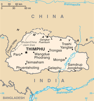
Bhutan_CIA_WFB_2010_map.png (३२६ × ३५० चित्राणु, फाइल आकार: १६ KB, माइम प्रकार: image/png)
| ई फाइल विकिमिडिया कमन्ससँ अछि। कमन्सकs विवरण पृष्ठसँ जानकारी एतए नीचाँ देखाएल गेल अछि। कमन्स एक फ्रि लाइसेन्स मिडिया फाइल परियोजना छि। अपने मद्ददतकs सकए छि। |

|
This map image could be re-created using vector graphics as an SVG file. This has several advantages; see Commons:Media for cleanup for more information. If an SVG form of this image is available, please upload it and afterwards replace this template with
{{vector version available|new image name}}.
It is recommended to name the SVG file “Bhutan CIA WFB 2010 map.svg”—then the template Vector version available (or Vva) does not need the new image name parameter. |
सङ्क्षेप
| जानकारी | Bhutan map from CIA World Factbook (since June 24, 2010) |
| दिनाङ्क | |
| स्रोत |
CIA World Factbook, converted from original GIF format |
| लेखक | United States Central Intelligence Agency |
| दूसरे संस्करण |
|
अधिकृत करब
This image is in the public domain because it contains materials that originally came from the United States Central Intelligence Agency's World Factbook.
|
 |
फाइल इतिहास
तखनका तिथि/ समए पर क्लिक करी जखनका फाइल देखबाक अछि
| तिथि/ समए | लघुचित्र | बीमसभ | प्रयोक्ता | समीक्षा | |
|---|---|---|---|---|---|
| अखनका | ०१:२५, ७ जुलाई २०१७ | | ३२६ × ३५० (१६ KB) | Ras67 | cropped, opt. |
| १७:४१, १२ मई २०१५ |  | ३३० × ३५४ (५२ KB) | Evolt | Updated to version as of April 24, 2015 | |
| १८:०२, २२ अगस्त २०११ |  | ३३० × ३५४ (१८ KB) | Zyxw | =={{int:filedesc}}== {{Information | Description = Bhutan map from CIA World Factbook ([http://web.archive.org/web/20100704230847/https://www.cia.gov/library/publications/the-world-factbook/geos/bt.html since June 24, 2010]) | Source = CIA World Factbook, |
फाइलक उपयोग
ई 2 पन्नासभमे ई फाइलक लिङ्क अछि:
विश्वव्यापी फाइल उपयोग
ई फाइल कऽ उपयोग निम्न दोसर विकिसभमे अछि:
- ace.wikipedia.org कऽ उपयोग पर
- af.wikipedia.org कऽ उपयोग पर
- als.wikipedia.org कऽ उपयोग पर
- ar.wikipedia.org कऽ उपयोग पर
- as.wikipedia.org कऽ उपयोग पर
- bcl.wikipedia.org कऽ उपयोग पर
- bh.wikipedia.org कऽ उपयोग पर
- bjn.wikipedia.org कऽ उपयोग पर
- bn.wikipedia.org कऽ उपयोग पर
- ca.wikipedia.org कऽ उपयोग पर
- cy.wikipedia.org कऽ उपयोग पर
- da.wikipedia.org कऽ उपयोग पर
- de.wikipedia.org कऽ उपयोग पर
- de.wiktionary.org कऽ उपयोग पर
- dv.wikipedia.org कऽ उपयोग पर
- dz.wikipedia.org कऽ उपयोग पर
- en.wikipedia.org कऽ उपयोग पर
- en.wiktionary.org कऽ उपयोग पर
- eo.wikipedia.org कऽ उपयोग पर
- es.wikipedia.org कऽ उपयोग पर
- eu.wikipedia.org कऽ उपयोग पर
- fa.wikipedia.org कऽ उपयोग पर
- fi.wikipedia.org कऽ उपयोग पर
ई फाइलक विश्वव्यापी उपयोगक अधिक जानकारी देखी।