
फाइल:Lasbela.PNG

ऐ पूर्वदृश्यक आकार: ६५६ × ६०० चित्राणु. दोसर resolutions: २६३ × २४० चित्राणु | ५२५ × ४८० चित्राणु | ६९९ × ६३९ चित्राणु।
पूर्ण आनन्तर्य (६९९ × ६३९ चित्राणु, फाइल आकार: २३ KB, माइम प्रकार: image/png)
| ई फाइल विकिमिडिया कमन्ससँ अछि। कमन्सकs विवरण पृष्ठसँ जानकारी एतए नीचाँ देखाएल गेल अछि। कमन्स एक फ्रि लाइसेन्स मिडिया फाइल परियोजना छि। अपने मद्ददतकs सकए छि। |

|
This locator map image could be re-created using vector graphics as an SVG file. This has several advantages; see Commons:Media for cleanup for more information. If an SVG form of this image is available, please upload it and afterwards replace this template with
{{vector version available|new image name}}.
It is recommended to name the SVG file “Lasbela.svg”—then the template Vector version available (or Vva) does not need the new image name parameter. |
सङ्क्षेप
| जानकारी |
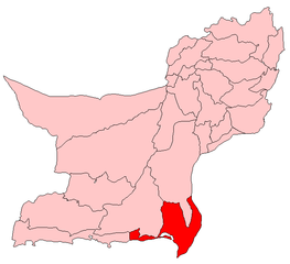
English: Map showing location of Lasbela District within Pakistan |
| दिनाङ्क | २२ जुलाई २००६ (original upload date) |
| स्रोत |
अपन काम (Original caption: "") |
| लेखक | Aarandir at en.wikipedia |
अधिकृत करब
Aarandir from en.wikipedia.org, इस कार्य के कॉपीराइट धारक, इसे निम्न लाइसेंस के अंतर्गत प्रकाशित करते हैं:
| ई फाइल लाइसेन्सड अछि एहि अन्तर्गत क्रिएटिभ कमन्स एट्रिब्युसन-सेयर अलाइक ३.० अनपोर्टेड लाईसेन्स । Subject to disclaimers. | ||
| एट्रिब्युसन: Aarandir from en.wikipedia.org | ||
| ||
| This licensing tag was added to this file as part of the GFDL licensing update. |

|
ई दस्तावेजके मुक्त सफ्टवेयर फाउन्डेसनद्वारा प्रकाशित जिएनयु मुक्त डक्युमेन्टेसन लाइसेन्सक संस्करण १.२ या नव (बिना कोनो इन्वेरिएन्ट अनुभागसभ आ आगु आ पिछुल्का आवरणक पाठ)के अन्तर्गत कपी, वितरित एवं/अथवा परिवर्तित करैक लेल अनुमति प्रदान कएल जाइत अछि । ई लाइसेन्सक एक प्रति जिएनयु मुक्त डक्युमेन्टेसन लाइसेन्स नामक अनुभागमे शामिल अछि । Subject to disclaimers. |
मूल अपलोड लॉग
The original description page was here. All following user names refer to en.wikipedia.
- 2006-07-22 10:04 Aarandir 699×639× (23677 bytes)
फाइल इतिहास
तखनका तिथि/ समए पर क्लिक करी जखनका फाइल देखबाक अछि
| तिथि/ समए | लघुचित्र | बीमसभ | प्रयोक्ता | समीक्षा | |
|---|---|---|---|---|---|
| अखनका | १८:२६, ११ जनवरी २०११ | | ६९९ × ६३९ (२३ KB) | Sentinel R | {{Information |Description=Map of Balochistan with Lasbela District highlighted |Source=http://en.wikipedia.org/wiki/File:Lasbela.PNG |Date= |Author=http://en.wikipedia.org/wiki/Special:Contributions/Aarandir |Permission={{GFDL-self-with-disclaimers|migra |
फाइलक उपयोग
एकोटा पन्ना नै अछि जे ई सञ्चिका सँ जुड़ल होए।