
फाइल:Relief Map of Poland.svg

पूर्वावलोकन PNG क आकार SVG फाइल: ६१७ × ६०० चित्राणु दोसर resolutions: २४७ × २४० चित्राणु | ४९४ × ४८० चित्राणु | ७९० × ७६८ चित्राणु | १,०५३ × १,०२४ चित्राणु | २,१०७ × २,०४८ चित्राणु | ८६१ × ८३७ चित्राणु।
पूर्ण आनन्तर्य (एसभिजी फाइल, मामूली रूपमे ८६१ × ८३७ चित्रकण, फाइलक आकार: ४ MB)
| ई फाइल विकिमिडिया कमन्ससँ अछि। कमन्सकs विवरण पृष्ठसँ जानकारी एतए नीचाँ देखाएल गेल अछि। कमन्स एक फ्रि लाइसेन्स मिडिया फाइल परियोजना छि। अपने मद्ददतकs सकए छि। |
सङ्क्षेप
| जानकारी |
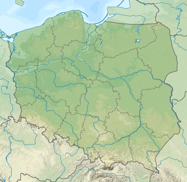
Deutsch: Positionskarte von Polen
Quadratische Plattkarte, N-S-Streckung 160 %. Geographische Begrenzung der Karte:
English: Location map of Poland
Equirectangular projection, N/S stretching 160 %. Geographic limits of the map:
|
| दिनाङ्क | |
| स्रोत |
अपन काम This vector image includes elements that have been taken or adapted from this file: This vector image includes elements that have been taken or adapted from this file: |
| लेखक |
TUBS |
| दूसरे संस्करण |
|
| SVG genesis | इस वेक्टर चित्र को Adobe Illustrator की मदद से TUBS द्वारा बनाया गया था। |


अधिकृत करब
मैं, इस कार्य का/की कॉपीराइट धारक, इसे निम्न लाइसेंस के अंतर्गत प्रकाशित करता/करती हूँ:
ई फाइल लाइसेन्सड अछि एहि अन्तर्गत क्रिएटिभ कमन्स एट्रिब्युसन-सेयर अलाइक ३.० अनपोर्टेड लाईसेन्स ।
- अहाँ मुक्त छी:
- साझा करी – रचनाक कपी, वितरित आ सञ्चारित करवाक लेल
- रिमिक्स करैक लेल – काम अनुकूलित करैक लेल
- निम्नलिखित कारणसभक अन्तर्गत:
- एट्रीब्यूसन – अहाँक रचनाक श्रेय लाइसेन्सकर्ता अथवा लेखकके बताएल गएल माध्यमसँ देबए पडत (मुदा ई प्रकार नै की वोसँ लागै कि ओ अहाँक अथवा अहाँकद्वारा रचनाक प्रयोग क समर्थन करैत अछि)।
- शेयर एलाइक – यदि अहाँ ई रचनामे कोनो परिवर्तन अथवा बदलाव करैत छी या एहिपर आधारित किछो रचित करैत छी तँ अहाँ निष्कर्ष स्वरूप बनल रचनाक मात्र एहि या एकर सामान कोनो same or compatible लाइसेन्सक अन्तर्गत वितरित करि सकैत छी।

|
I'd greatly appreciate, that you attribute this media file to Wikimedia Commons, if used outside Wikipedia or Commons. For use in publications such as books, newspapers, blogs, websites, please insert here the following line:
|
फाइल इतिहास
तखनका तिथि/ समए पर क्लिक करी जखनका फाइल देखबाक अछि
| तिथि/ समए | लघुचित्र | बीमसभ | प्रयोक्ता | समीक्षा | |
|---|---|---|---|---|---|
| अखनका | ०५:०५, १ दिसम्बर २०२१ | | ८६१ × ८३७ (४ MB) | Puck04 | fixed SVG code (was "W3C-invalid") + cleanup using text editor; contains raster graphics however |
| ०२:३९, ४ फरबरी २०२१ |  | ८६१ × ८३७ (४.१८ MB) | SANtosito | Vectorized topo | |
| ०३:३७, १ दिसम्बर २०११ |  | ८६१ × ८३७ (४.८७ MB) | TUBS | == {{int:filedesc}} == {{Information |Description={{en|Relief map of Poland}} Equirectangular projection, N/S stretching 160 %. Geographic limits of the map: * N: 55.2° N * S: 48.7° N * W: 13.8° E * E: 24.5° E |Source={{own}}{{Adobe Il |
फाइलक उपयोग
ई 2 पन्नासभमे ई फाइलक लिङ्क अछि:
विश्वव्यापी फाइल उपयोग
ई फाइल कऽ उपयोग निम्न दोसर विकिसभमे अछि:
- ab.wikipedia.org कऽ उपयोग पर
- als.wikipedia.org कऽ उपयोग पर
- ar.wikipedia.org कऽ उपयोग पर
- av.wikipedia.org कऽ उपयोग पर
- azb.wikipedia.org कऽ उपयोग पर
- az.wikipedia.org कऽ उपयोग पर
- Şablon:Yer xəritəsi Polşa
- Əyri meşə
- Slovinski Milli Parkı
- Dzivna boğazı
- Yamno gölü
- Baltik dili
- Şablon:Dil (coğrafiya)
- Şablon:Dil (coğrafiya)/doc
- Xel dili
- Blendovka səhrası
- Morskie Oko gölü
- Belka-Snejna mağarası
- Karsibur adası
- Ambarlar adası
- Qrabovski adası
- Haliç dağı
- Jives gölü
- Rozeve burnu
- Lısa-Gora dağı
- Avqustovskaya puşa
- Tuxolskie borı
- Rastoçe
- Rominten meşəsi
- Solina gölü
- Qartal Yuvası təbiət parkı
- ban.wikipedia.org कऽ उपयोग पर
- Taman Nasional Tatra, Polandia
- Taman Nasional Bieszczady
- Lis taman nasional ring Polandia
- Taman Nasional Wielkopolska
- Taman Nasional Pieniny (Polandia)
- Taman Nasional Gorce
- Taman Nasional Babia Góra
- Taman Nasional Białowieża
- Taman Nasional Biebrza
- Taman Nasional Kampinos
- Taman Nasional Narew
- Taman Nasional Wigry
- Taman Nasional Magura
- Taman Nasional Roztocze
- Taman Nasional Polesie
- Taman Nasional Świętokrzyski
- Taman Nasional Ojców
ई फाइलक विश्वव्यापी उपयोगक अधिक जानकारी देखी।