
फाइल:World map of countries by literacy rate.svg

पूर्वावलोकन PNG क आकार SVG फाइल: ८०० × ३५३ चित्राणु दोसर resolutions: ३२० × १४१ चित्राणु | ६४० × २८३ चित्राणु | १,०२४ × ४५२ चित्राणु | १,२८० × ५६५ चित्राणु | २,५६० × १,१३० चित्राणु | ९४० × ४१५ चित्राणु।
पूर्ण आनन्तर्य (एसभिजी फाइल, मामूली रूपमे ९४० × ४१५ चित्रकण, फाइलक आकार: १.५ MB)
| ई फाइल विकिमिडिया कमन्ससँ अछि। कमन्सकs विवरण पृष्ठसँ जानकारी एतए नीचाँ देखाएल गेल अछि। कमन्स एक फ्रि लाइसेन्स मिडिया फाइल परियोजना छि। अपने मद्ददतकs सकए छि। |


|
This image is expected to always be the most recent one. Feel free to update it when needed.
|
| जानकारी |
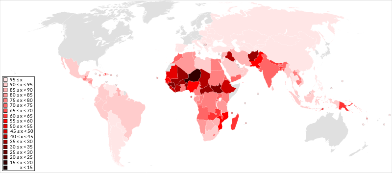
English: A detailed Robinson projection SVG map shaded by country using an equally distributed red palette according to their literacy rate. x = literacy rate and countries without data are light grey. |
||
| दिनाङ्क | (First uploaded) | ||
| स्रोत | File:BlankMap-World6, compact.svg (map) and List of countries by literacy rate (data) | ||
| लेखक | Jolly Janner | ||
| अनुमति (ई फाइलक पुनः उपयोग) |
|
||
| दूसरे संस्करण |
|


फाइल इतिहास
तखनका तिथि/ समए पर क्लिक करी जखनका फाइल देखबाक अछि
| तिथि/ समए | लघुचित्र | बीमसभ | प्रयोक्ता | समीक्षा | |
|---|---|---|---|---|---|
| अखनका | ०९:४७, २१ जुलाई २०१८ | | ९४० × ४१५ (१.५ MB) | Jolly Janner | Update Iraq (79.7% → 43.7%) |
| १४:०७, २० नवम्बर २०१५ |  | ९४० × ४१५ (१.५ MB) | Jolly Janner | Update per difference in UNESCO and CIA: DR of Congo now 75-80; Egypt now 75-80; Guatemala now 75-80; Mexico now 90-95; Morocco now 70-75; Paraguay now 95-100; Seychelles now 95-100; South Sudan now 30-35; Tanzania now 80-85; Uganda now 70-75 | |
| १०:२५, २० नवम्बर २०१५ |  | ९४० × ४१५ (१.५ MB) | Jolly Janner | Update per article. Addition of Antigua & Barbuda, Belize, Cayman Islands, Cote d'Ivoire, Guadeloupe, Guam, Guyana, Jamaica, Martinique, Reunion and Slovakia. Removal of Djibouti and Czech Republic | |
| ०३:२३, ३ नवम्बर २०१५ |  | ९४० × ४१५ (१.५ MB) | Jolly Janner | Removed Antarctica (compact version of map) | |
| ०३:०६, ३ नवम्बर २०१५ |  | ८६३ × ४४३ (१.६१ MB) | Jolly Janner | {{Notice|'''Editor's note:''' This map is saved in human-editable plain text format to make updating easier for everyone. Save and open with Notepad and simply '''cut''' and paste the country code from one class to another when updating then save and u... |
फाइलक उपयोग
ई पृष्ठमे ई फाइलक लिङ्क अछि:
विश्वव्यापी फाइल उपयोग
ई फाइल कऽ उपयोग निम्न दोसर विकिसभमे अछि:
- ar.wikipedia.org कऽ उपयोग पर
- ast.wikipedia.org कऽ उपयोग पर
- ba.wikipedia.org कऽ उपयोग पर
- cy.wikipedia.org कऽ उपयोग पर
- el.wikipedia.org कऽ उपयोग पर
- en.wikipedia.org कऽ उपयोग पर
- fa.wikipedia.org कऽ उपयोग पर
- fr.wikipedia.org कऽ उपयोग पर
- hy.wikipedia.org कऽ उपयोग पर
- ia.wikipedia.org कऽ उपयोग पर
- km.wikipedia.org कऽ उपयोग पर
- ko.wikipedia.org कऽ उपयोग पर
- lfn.wikipedia.org कऽ उपयोग पर
- lv.wikipedia.org कऽ उपयोग पर
- mk.wikipedia.org कऽ उपयोग पर
- Википедија:Избрана статија/2018
- Писменост
- Википедија:Кандидати за избрана статија/Писменост
- Википедија:Избрана статија/2018/37
- Википедија:Избрана статија/2021
- Википедија:Избрана статија/2021/46
- Википедија:Избрана статија/2022
- Википедија:Избрана статија/2022/49
- Википедија:Избрана статија/2023
- Википедија:Избрана статија/2023/12
- ru.wikipedia.org कऽ उपयोग पर
- sv.wikipedia.org कऽ उपयोग पर
- ta.wikipedia.org कऽ उपयोग पर
- tr.wikipedia.org कऽ उपयोग पर
- www.wikidata.org कऽ उपयोग पर
- zh.wikipedia.org कऽ उपयोग पर