
फाइल:Khyber Pakhtunkhwa Districts.svg

पूर्वावलोकन PNG क आकार SVG फाइल: ३८६ × ५९९ चित्राणु दोसर resolutions: १५४ × २४० चित्राणु | ३०९ × ४८० चित्राणु | ४९४ × ७६८ चित्राणु | ६५९ × १,०२४ चित्राणु | १,३१९ × २,०४८ चित्राणु | ६४४ × १,००० चित्राणु।
पूर्ण आनन्तर्य (एसभिजी फाइल, मामूली रूपमे ६४४ × १,००० चित्रकण, फाइलक आकार: ८७ KB)
| ई फाइल विकिमिडिया कमन्ससँ अछि। कमन्सकs विवरण पृष्ठसँ जानकारी एतए नीचाँ देखाएल गेल अछि। कमन्स एक फ्रि लाइसेन्स मिडिया फाइल परियोजना छि। अपने मद्ददतकs सकए छि। |
सङ्क्षेप
| जानकारी |
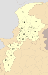
English: The up shown map is of October 2014. It contains only 24 districts and it doesn't contain a new District Torghar. The new map which include 25 districts and created in December 2014 was available here: Khyber Pakhtunkhwa Districts 2014.png |
| दिनाङ्क | |
| स्रोत | अपन काम |
| लेखक | Schajee |
| SVG genesis | इस वेक्टर चित्र को Inkscape की मदद से बनाया गया था, or with something else. |
अधिकृत करब
| मैं, इस कार्य का/की कॉपीराइट धारक, इस कार्य को सार्वजनिक डोमेन में प्रकाशित करता/करती हूँ। यह पूरे विश्व में लागू होता है। कुछ देशों में यह कानूनी तौर पर नहीं हो सकता है; ऐसा हो तो: मैं सभी को इस कार्य का इस्तेमाल किसी भी उद्देश्य से, बिना किसी बाधाओं के इन शर्तों के कानून द्वारा अनिवार्य किए तक करने की अनुमति देता/देती हूँ। |
फाइल इतिहास
तखनका तिथि/ समए पर क्लिक करी जखनका फाइल देखबाक अछि
| तिथि/ समए | लघुचित्र | बीमसभ | प्रयोक्ता | समीक्षा | |
|---|---|---|---|---|---|
| अखनका | ०५:१३, २० नवम्बर २०१९ | | ६४४ × १,००० (८७ KB) | আফতাবুজ্জামান | File uploaded using svgtranslate tool (https://tools.wmflabs.org/svgtranslate/). Added translation for bn. |
| १९:४९, ३१ जुलाई २०१६ |  | ६४४ × १,००० (५६ KB) | Furfur | enlarged the numbers, such that they can be read in the preview | |
| २०:१६, २० जनवरी २०१५ |  | ६४४ × १,००० (६२ KB) | Ciaurlec | Reverted to version as of 21:15, 10 October 2010 | |
| ०८:५९, ३ दिसम्बर २०१४ |  | ८०० × १,२४३ (५२१ B) | UsmanKhan | Included the new District "Torghar". | |
| ०३:००, ११ अक्टुबर २०१० |  | ६४४ × १,००० (६२ KB) | Schajee | {{Information |Description={{en|1=Districts of Khyber Pakhtunkhwa as of Oct 2010}} |Source={{own}} |Author=Schajee |Date=2010-10-10 |Permission= |other_versions= }} Category:Maps of Pakistan |
फाइलक उपयोग
ई 5 पन्नासभमे ई फाइलक लिङ्क अछि:
विश्वव्यापी फाइल उपयोग
ई फाइल कऽ उपयोग निम्न दोसर विकिसभमे अछि:
- bn.wikipedia.org कऽ उपयोग पर
- সোয়াত জেলা
- টেমপ্লেট:খাইবার পাখতুনখোয়ার জেলা
- মালাকান্দ জেলা
- হরিপুর জেলা
- পেশাওয়ার জেলা
- বান্নু জেলা
- লাক্কি মারওয়াত জেলা
- ডেরা ইসমাইল খান জেলা
- উত্তর ওয়াজিরিস্তান
- দক্ষিণ ওয়াজিরিস্তান
- ট্যাঙ্ক জেলা
- অ্যাবোটাবাদ জেলা
- বট্টগ্রাম জেলা
- কলাই-পলাস জেলা
- নিম্ন কোহিস্তান জেলা
- মনসেহরা জেলা
- তরঘার জেলা
- উচ্চ কোহিস্তান জেলা
- হঙ্গু জেলা
- কারাক জেলা
- কোহাত জেলা
- কুররাম জেলা
- ওরাকজাই জেলা
- বাজৌর জেলা
- বুনের জেলা
- চিত্রাল জেলা
- নিম্ন দির জেলা
- শাংলা জেলা
- উচ্চ দির জেলা
- মর্দান জেলা
- সোয়াবি জেলা
- চরসাদ্দা জেলা (পাকিস্তান)
- খাইবার জেলা
- মোহমান্দ জেলা
- নওশেরা জেলা
- খাইবার পাখতুনখোয়ার জেলার তালিকা
- en.wikipedia.org कऽ उपयोग पर
- fa.wikipedia.org कऽ उपयोग पर
ई फाइलक विश्वव्यापी उपयोगक अधिक जानकारी देखी।