मैथिली विकिपिडियासँ, एक मुक्त विश्वकोश
सन् २०१४ धरि ब्राजिलक १९ टा सम्पदाक संयुक्त राष्ट्र शैक्षिक, वैज्ञानिक एवं सांस्कृतिक सङ्गठन (युनेस्को)द्वारा विश्व सम्पदा क्षेत्रमे मान्यता प्रदान कएल गेल अछि ।[१]
आकृति:World Heritage Sites in Bolivia map
युनेस्कोद्वारा विश्व सम्पदा क्षेत्र घोषित कएल बोलिभियाक सांस्कृतिक आ प्राकृतिक स्थलसभक सूची:
- नाम: विश्व सम्पदा समितिद्वारा देल नाम
- क्षेत्र: राष्ट्रक इलाका आ क्षेत्र
- समय: स्थापना भेल वर्ष
- युनेस्को डेटा: विश्व सम्पदा क्षेत्रमे समावेश कएल गेल वर्ष आ मापदण्ड
- विवरण: सम्पदा क्षेत्रक बारेमे संक्षिप्त विवरण
* सीमा पार क्षेत्रसभ
| सम्पदा क्षेत्र
|
चित्र
|
स्थान
|
मापदण्ड
|
क्षेत्रफल
हे (एकड)
|
वर्ष
|
विवरण
|
सन्दर्भसभ
|
| एटलान्टिक वन दक्षिण-पूर्व निकुञ्ज
|
|
साओ पाउलो, रियो
 ब्राजिल ब्राजिल
२४°१०′द॰ ४८°०′प॰ / २४.१६७°S ४८.०००°W / -24.167; -48.000 (Atlantic Forest South-East Reserves)}}
|
प्राकृतिक: vii, ix, x
|
7005468193000000000४,६८,१९३ (११,५६,९३०); मध्यवर्ती क्षेत्र १२,२३,५५७ (३०,२३,४८०)
|
१९९९
|
|
[२]
|
| ब्रसिलिया
|

|
Brazil !फेडेरल जिला ,
ब्राजिल
१५°४७′द॰ ४७°५४′प॰ / १५.७८३°S ४७.९००°W / -15.783; -47.900 (Brasília)
|
सांकृतिक: i, iv
|
|
१९८७
|
|
[३]
|
| ब्रजिलियाली एटलान्टिक टापुसभ: फर्नान्डो दे नोरोन्हा आ एटोल दास रोकास निकुञ्जसभ
|
|
ZZZ !रियो ग्रान्ड,
ब्राजिल
३°५१′२९″द॰ ३२°२५′३०″प॰ / ३.८५८०६°S ३२.४२५००°W / -3.85806; -32.42500 (Brazilian Atlantic Islands: Fernando de Noronha and Atol das Rocas Reserves)
|
प्राकृतिक:vii, ix, x
|
7004422700000000000४२,२७० (१,०४,५००); मध्यवर्ती क्षेत्र १,४०,७१३ (३,४७,७१०)
|
2001 !२००१
|
|
[४]
|
| amazon central !केन्द्रीय अमेजन संरक्षण परिसर
|

|
Amazonas !अमेजोनास,
ब्राजिल
२°२०′०″द॰ ६२°०′३०″प॰ / २.३३३३३°S ६२.००८३३°W / -2.33333; -62.00833 (Central Amazon Conservation Complex)
|
प्राकृतिक:ix, x
|
7006532301800000000५३,२३,०१८ (१,३१,५३,४६०)
|
2000 !२०००
|
|
[५]
[६]
|
| केर्रादो संरक्षित क्षेत्रसभ: चपादा दोस भेदिरोस राष्ट्रिय निकुञ्ज आ इमास राष्ट्रिय निकुञ्जसभ
|

|
Goias !केन्द्रीय ब्राजिल,
ब्राजिल
१४°०′२०″द॰ ४७°४१′५″प॰ / १४.००५५६°S ४७.६८४७२°W / -14.00556; -47.68472 (Cerrado Protected Areas: Chapada dos Veadeiros and Emas National Parks)
|
प्राकृतिक: ix, x
|
7005367356000000000३,६७,३५६ (९,०७,७६०)
|
2001 !२००१
|
|
[७]
|
| डिस्कभरी कोस्ट एटलान्टिक वन आरक्ष
|

|
ZZZ !बहिया,
ब्राजिल
१६°३०′द॰ ३९°१५′प॰ / १६.५००°S ३९.२५०°W / -16.500; -39.250 (Discovery Coast Atlantic Forest Reserves)
|
प्राकृतिक: ix, x
|
7005111930000000000१,११,९३० (२,७६,६००)
|
1999 !१९९९
|
|
[८]
|
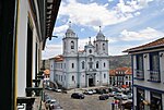
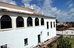
| salvador de bahia !साल्भाडोर दे बाहियाक एतिहासिक केन्द्र
|

|
Bahia !बाहिया राज्य,
ब्राजिल
१२°५८′०″द॰ ३८°३०′०″प॰ / १२.९६६६७°S ३८.५००००°W / -12.96667; -38.50000 (Historic Centre of Salvador de Bahia)
|
सांस्कृतिक:iv, vi
|
|
1985 !१९८५
|
|
[९]
|
| são luís !साओ लुइसक एतिहासिक केन्द्र
|

|
Maranhao !मारानहाओ राज्य,
ब्राजिल
२°३०′५१″द॰ ४४°१८′९″प॰ / २.५१४१७°S ४४.३०२५०°W / -2.51417; -44.30250 (Historic Centre of Salvador de Bahia)
|
सांस्कृतिक:iii, iv, v
|
|
1997 !१९९७
|
|
[१०]
|
| diamantina !डायमनटिनाक एतिहासिक सहरक केन्द्र
|
|
Minas Gerais !मिनास गेरियास,
ब्राजिल
१८°४०′०″द॰ ४३°३६′०″प॰ / १८.६६६६७°S ४३.६००००°W / -18.66667; -43.60000 (Historic Centre of the Town of Diamantina)
|
सांस्कृतिक: ii, iv
|
7001290000000000000२९ (७२)
|
1999 !१९९९
|
|
[११]
|
| goiás !गोइसक एतिहासिक सहरक केन्द्र
|
|
Goias !गोइस,
ब्राजिल
१५°५६′०″द॰ ५०°८′०″प॰ / १५.९३३३३°S ५०.१३३३३°W / -15.93333; -50.13333 (Historic Centre of the Town of Goiás)
|
सांस्कृतिक: ii, iv
|
7001400000000000000४० (९९); मध्यवर्ती क्षेत्र ४४ (११०)
|
2001 !२००१
|
|
[१२]
|
| olinda !ओलिन्डाक एतिहासिक सहरक केन्द्र
|

|
Pernambuco !पर्नामबुओ,
ब्राजिल
८°०′४८″द॰ ३४°५०′४२″प॰ / ८.०१३३३°S ३४.८४५००°W / -8.01333; -34.84500 (Historic Centre of the Town of Olinda)
|
सांस्कृतिक: ii, iv
|
7002120000000000000१२० (३००); buffer zone ९२० (२,३००)
|
1982 !१९८२
|
|
[१३]
|
| ouro preto !अउरो प्रेटोक एतिहासिक सहर
|

|
Minas Gerais !मिनास गेरियास,
ब्राजिल
२०°२३′२०″द॰ ४३°३०′२०″प॰ / २०.३८८८९°S ४३.५०५५६°W / -20.38889; -43.50556 (Historic Town of Ouro Preto)
|
सांस्कृतिक: i, iii
|
|
1980 !१९८०
|
|
[१४]
|
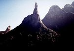
| इगुआकु राष्ट्रिय निकुञ्ज
|
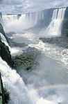
|
Parana !पराना,
ब्राजिल
२५°४१′द॰ ५४°२६′प॰ / २५.६८३°S ५४.४३३°W / -25.683; -54.433 (Iguaçu National Park)
|
सांस्कृतिक:vii, x
|
7005170086000000000१,७०,०८६ (४,२०,२९०)
|
1986 !१९८६
|
|
[१५]
|
| guarani !गुवारानिसक हेसुइट मिसनसभ: सान इग्नासियो मिनी, सान्ता आना, नुयेस्त्रा सेन्योरा दे लोरेटो आ सान्ता मारिया मायोर (अर्जेन्टिना), साओ मिगुएल दास मिस्सोएस (ब्राजिल)
|

|
ZZZ !मिसन प्रान्त,  अर्जेन्टिना* आ रियो ग्राण्ड, ब्राजिल* अर्जेन्टिना* आ रियो ग्राण्ड, ब्राजिल*
२८°३२′३६″द॰ ५४°१५′५७″प॰ / २८.५४३३३°S ५४.२६५८३°W / -28.54333; -54.26583 (Jesuit Missions of the Guaranis: San Ignacio Mini, Santa Ana, Nuestra Señora de Loreto and Santa Maria Mayor (Argentina), Ruins of Sao Miguel das Missoes (Brazil))
|
सांस्कृतिक:iv
|
|
1983 !१९८३
|
|
[१६]
[१७]
|
| पान्टाना संरक्षित क्षेत्र
|
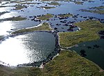
|
Mato Grosso !माटो ग्रोसो,
ब्राजिल
१७°४३′द॰ ५७°२३′प॰ / १७.७१७°S ५७.३८३°W / -17.717; -57.383 (Pantanal Conservation Area)
|
सांस्कृतिक: vii, ix, x
|
7005187818000000000१,८७,८१८ (४,६४,११०)
|
2000 !२०००
|
|
[१८]
|
| रियो दी जेनेरियो: हिमालय आ समुद्रक बिचमे कारिओक परिदृश्य
|

|
Rio de Janeiro !रियो दी जेनेरियो,
ब्राजिल
२२°५६′५२″द॰ ४३°१७′२९″प॰ / २२.९४७७८°S ४३.२९१३९°W / -22.94778; -43.29139 (Rio de Janeiro)
|
सांस्कृतिक: vi
|
7003724900000000000७,२४९ (१७,९१०); मध्यवर्ती क्षेत्र ८,६२१ (२१,३००)
|
2012 !२०१२
|
|
[१९]
|
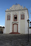
| congonhas !बोम जिसस दो कोङ्गोनहासक तिर्थस्थल
|

|
Minas Gerais !कोङ्गोनहास,
ब्राजिल
२०°२९′५९″द॰ ४३°५१′२८″प॰ / २०.४९९७२°S ४३.८५७७८°W / -20.49972; -43.85778 (Sanctuary of Bom Jesus do Congonhas)
|
प्राकृतिक: i, iv
|
|
1985 !१९८५
|
|
[२०]
|
| são cristóvão !साओ क्रिस्टोभाओमे रहल साओ फ्रान्सिस्क स्क्वायर
|
|
Sergipe !सेरगिप,
ब्राजिल
११°०′५८″द॰ ३७°१२′३६″प॰ / ११.०१६११°S ३७.२१०००°W / -11.01611; -37.21000 (São Francisco Square in the Town of São Cristóvão)
|
सांस्कृतिक:ii, iv
|
7000300000000000000३.०० (७.४); मध्यवर्ती क्षेत्र २,५०० (६,२००)
|
2010 !२०१०
|
|
[२१]
|
| सेर्रा दा क्यापिभारा राष्ट्रिय निकुञ्ज
|

|
Piaui !पियाउ,
ब्राजिल
८°२५′०″द॰ ४२°२०′०″प॰ / ८.४१६६७°S ४२.३३३३३°W / -8.41667; -42.33333 (Serra da Capivara National Park)
|
सांस्कृतिक:iii
|
1991 !१९९१
|
|
|
[२२]
|
आकृति:अमेरिकाका विश्व सम्पदा क्षेत्रसभक सूची
आकृति:World Heritage Sites in Brazil


